Preliminary findings point to a snow avalanche, glacier-related landslide and repeated blockage of mountain streams as major factors behind destructive flood surges in Gorkha.
GORKHA, NEPAL - A preliminary technical assessment of the recent Gorkha-Budhi Gandaki flood has identified a massive high-altitude landslide involving snow, water and debris, followed by the repeated obstruction and release of river flows, as key factors contributing to the destructive flood surges in the region.
According to the technical report, the event occurred at approximately 4:20 AM on Ashoj 25, 2083 (Bikram Sambat), in the upper reaches of the Undilung Khola in Chumnubri Rural Municipality-6, Gorkha District, in the steep mountain stream between Chamar Himal and Syerangi Himal.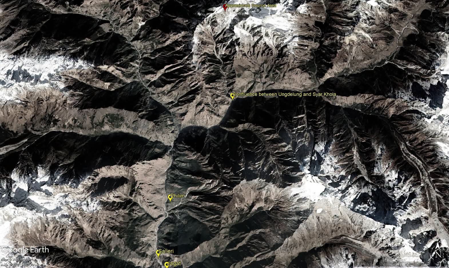 The assessment indicates that a snow avalanche originated at an altitude of approximately 6,000 metres, accompanied by a large landslide involving glacier ice and debris at around 5,500 metres. The source area lies within the Tibetan Tethys Himalaya, where comparatively weak rock formations are present.
Several smaller landslides reportedly occurred in the area both before and after the main event.
Massive debris flow and river blockage
The report states that the mixture of snow, water and debris travelled southward from the upper reaches of the Undilung Khola, spreading along both sides of the steep stream and reaching approximately 300 metres up its banks.
A large quantity of debris accumulated at the narrow confluence of the Undilung Khola and the Syar Khola, at an elevation of approximately 2,000 metres. This accumulation appears to have repeatedly obstructed and released the flow of the Syar Khola, potentially contributing to sudden surges downstream.
A similar process may also have occurred at the confluence of the Syar Khola and the Budhi Gandaki River. The repeated obstruction and release of water and debris may have contributed to multiple flood surges along the Budhi Gandaki River.
However, the assessment emphasises that the large volume of debris carried by the Undilung Khola appears to have played a particularly significant role in generating the destructive flood surges, rather than water accumulated behind the blockage of the Syar Khola alone.
Largest flood surge reached Salleri at around 6:30 AM
According to the report, the first debris-laden flood reached Salleri at approximately 4:30 AM. The largest surge, estimated to have reached a height of around 20-25 metres at the hydropower camp in Salleri, arrived at approximately 6:30 AM and swept away the camp.
The largest surge reportedly caused significant damage in downstream areas, particularly in Jagat, where several buildings were affected. Infrastructure damage also included permanent bridges over the Soti Khola and the Budhi Gandaki River.
Field observations indicate that the flow of the Syar Khola had stopped approximately one hour before the largest flood surge arrived. Water had reportedly accumulated over a stretch of approximately 1.5 kilometres in the upper reaches of the Syar Khola.
Smaller flood surges continued even after the largest surge had passed, indicating that the event involved multiple waves of water and debris rather than a single flood pulse.
High soil content gave the flood characteristics of a viscous mudflow
The technical assessment highlights an important characteristic of the flood: its unusually high soil content compared with the amount of sand and small to large stones.
This composition gave the flow characteristics of a viscous mudflow, a dense mixture of water and fine material that behaves differently from an ordinary river flood. The report attributes the high soil content primarily to the nature of the sedimentary rock formations and debris in the source area.
Such debris-rich flows can pose severe risks to settlements, bridges, hydropower infrastructure and other structures situated along narrow mountain valleys.
Preliminary assessment estimates energy equivalent to a magnitude 3.5 earthquake
According to the Department of Mines and Geology's preliminary assessment, the landslide appears to have generated energy equivalent to that of an earthquake of approximately magnitude 3.5.
This estimate is a preliminary assessment of the energy associated with the landslide event; it should not be interpreted as confirmation that an earthquake of that magnitude occurred.
Importance of understanding cascading mountain hazards
The findings highlight how multiple interconnected processes in high mountain environments can combine to produce destructive downstream impacts. A snow avalanche or landslide can mobilise large quantities of ice, soil and rock, obstruct a stream, and subsequently trigger sudden surges when the accumulated material or water is released.
The Gorkha-Budhi Gandaki event underscores the importance of high-altitude hazard monitoring, systematic geological and glacial assessments, field-based investigations and early-warning systems capable of communicating risks to communities living downstream.
The preliminary findings provide an important basis for understanding the sequence of events behind the flood. Further detailed investigation would help clarify the precise mechanisms of the landslide, the extent of river blockage, the volume of debris involved and the contribution of each process to the downstream damage.
As Nepal continues to face complex mountain hazards, strengthening scientific monitoring, local preparedness and risk-informed infrastructure planning remains essential to reducing future disaster impacts.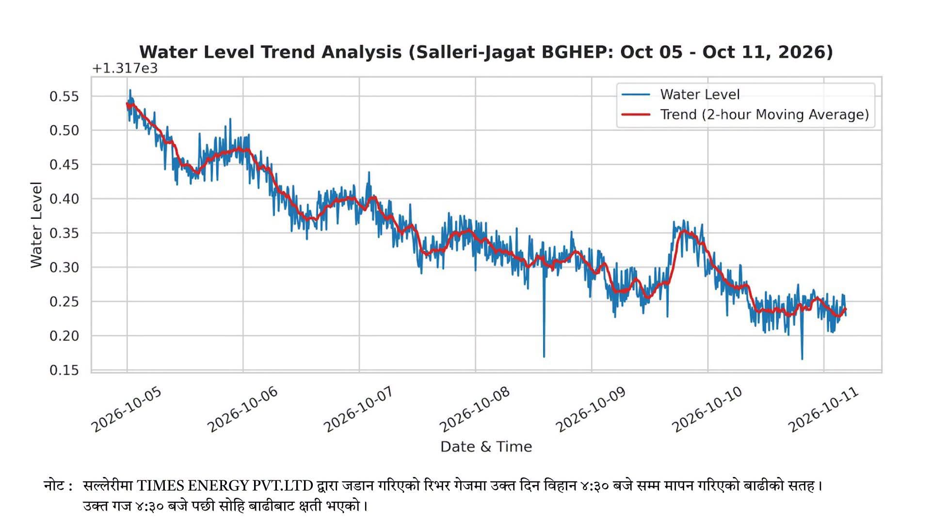
Source: Preliminary technical report on the Gorkha-Budhi Gandaki flood, including field observations and the initial assessment attributed to Nepal's Department of Mines and Geology.
#GorkhaFlood #BudhiGandaki #Nepal #DisasterRiskReduction #Landslide #GlacialHazards #MountainHazards #FloodRisk #EarlyWarningSystems #ClimateResilience #GeologicalHazards #DisasterPreparedness #EnvironmentalNews #EcosphereNews